The Elusive Timothy Pont (c.1564-c.1614)
by Dr. Andrew Grout
Unfortunately, few of the details of Timothy Pont's life are recorded. In fact, there are just about a dozen fixed dates for his life, details of which are given in Timothy Pont: the facts, in The Pont family: a summary, and in The Pont family: a detailed report. We do not know exactly when or where he was born, although his father, the Reverend Robert Pont (1524-1606), lived at Shiresmill, Fife, and Timothy, his second son, may perhaps have been born there. Timothy's father was a remarkable and important man in his own right. An eminent and influential Scottish clergyman, practising lawyer, and writer, Robert Pont was also deeply interested in astrology, chronology, and the natural world (Williamson, 1994). In 1574, Robert bestowed a modest annual grant of church funds on Timothy, which presumably gave his son a certain degree of independence. In 1580 Timothy matriculated (enrolled) at St Andrews University. It was here that he was possibly taught 'the making of the cartes [maps] universall and particular, by William Welwood, Professor of both Canon and Civil Law (Yeoman, 1996). Pont went on to graduate in 1583, and in that year his father again renewed his annual grant to him. We do not know exactly when Timothy first began his mapping of Scotland. The sole dated Pont manuscript map is his map of Clydesdale (covering Glasgow and the county of Lanark), known as Pont 34. On this, Pont has written '...Sept et Octob: 1596 Descripta'. There is some evidence that he may have completed his travels by April of that year (Megaw, 1969), and it is possible that he began his mapping shortly following his graduation. In 1592 he received a commission to conduct a mineral survey in Orkney and Shetland, and he may well have accompanied his father on a visit to Orkney during the following year. It was also in 1593 that his father once again supported him financially by assigning to him the bulk of an annuity he received from Edinburgh Town Council. In 1600 or 1601 Timothy was appointed church minister of the parish of Dunnet in Caithness, in the far northeast of the Scottish mainland. His brother Zachary became the minister of the adjacent parish of Bower shortly thereafter. Timothy is recorded as drawing his annuity in 1605, and in 1609 he applied, unsuccessfully, for a grant of plantation lands in Ulster (Northern Ireland). A year later he was still recorded as living at Dunnet, and in 1611 he signed a bond in Edinburgh relating to a loan to the Earl of Caithness. By 1614 he had been replaced as minister of the parish of Dunnet, and by March 1615 his wife Isobel was described as his 'relict' or widow when collecting a debt due to Timothy in Tongue, confirming Timothy's death by this time. His only monument, other than his surviving manuscripts, is a marble plaque erected to celebrate his memory in Dunnet Church. There are two separate maps of parts of Perthshire on this sheet, separated by a faint ink line. They are known as Pont 21(1) and Pont 21(2). Pont 21(1) shows the River Almond from a point just west of Perth (not shown) in the east to the Sma' Glen (not named on the map), west of Butthendy (Buchanty) in the west - a distance of about 15km. South of the river, the map extends to Cluthy (Clathy). Pont 21(2) includes the drainage basin of the River Earn from its headwaters west of Loch Eryn (Loch Earn) in the west to a point just east of Duply Cast.[le] (Dupplin Castle) near Aberdalgie, south west of the town of Perth (not shown) in the east. The northern margin encloses Binchoynie Hill (Ben Chonzie, a 3,048ft hill) and the area around Loch Turret. Along the southern margin can be seen Blackford, south west of modern Auchterarder, and the Water of May around Path of Condie in the south east. 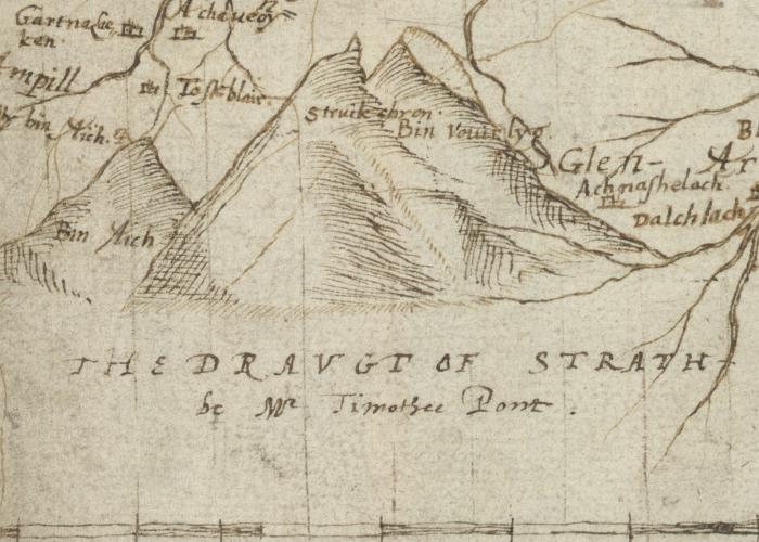 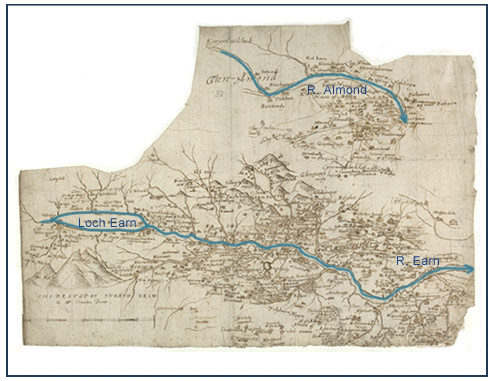 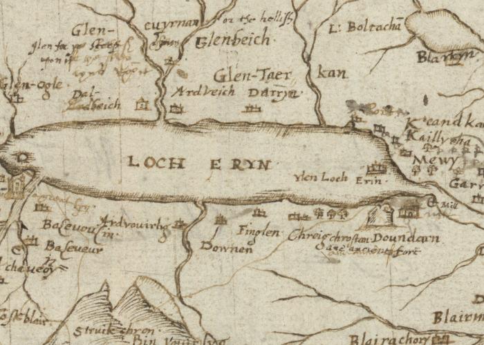 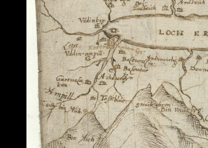 Pont 21 : Lower Glen Almond; Strathearn Pont 21(1) Lower Glen Almond " Pont has used a wide variety of symbols to depict smaller settlements, and larger structures such as Methven Castle are often sketched. " A cross has been drawn across this map, perhaps indicating that it had been superseded or that it was considered inaccurate. " Five of Gordon's manuscript maps include part of the area: 2, 4, 6, 41, and 43. " See also the printed map of Braid-Allaban by Blaeu. It" This area is covered also by Pont 22 (front). includes the very south west part of this area. Pont 21(2) Strathearn " Much of this map has been over-drawn in dark ink, probably by Robert Gordon. It is likely that Gordon also added the scale bar (lower left), and the title adjacent: The Draught of Strath Erin be Mr Timothee Pont " This map shows two bridges. One spans the River Earn at Kombre (Comrie) (centre), and the other crosses a small river just east of Kreef (Crieff) (centre right). " There are several interesting notes on this sheet. One such, above Loch Eryn (Loch Earn), is re-written in the hand of Gordon. It says: Glen cuyrnan or the hellish glen for [th]e steep lyns upon it " At the south east end of Loch Earn, Pont has drawn ane antient fort of Doundarn (Dundurn). " Some of the other notes are transcribed by Stone (1989). " The south east of this area is also covered by Pont 22 (front) " Three manuscript maps by Gordon cover this area but include relatively little information. They are sheets: 2, 6, and 48. " None of Blaeu's printed maps provide coverage of the area. Hence, this map by Pont is all the more valuable as a unique historical source. Maps by Blaeu and Gordon can be accessed via the National Library of Scotland's Digital Library. Text derived in part from Jeffrey C. Stone's The Pont Manuscript Maps of Scotland, published by Map Collector Publications Ltd in 1989. SOURCE: National Library of Scotland; web site: http://www.nls.uk/pont/bio/elusive.html |